


DRAGON BLOOD TRAIL
Socotra Island | YEMEN
HIGH POINT
1000 m
DIFFICULTY (1/10)
9
DISTANCE
370 Km
DAYS
10
% SINGLETRACK
1%
% UNPAVED
80%
TOTAL ASCENT
5083 m
% RIDEABLE TIME
96%
Between the Arabian Peninsula and the Horn of Africa, there’s a wild and incredible island floating in the Indian Ocean. Dragon Blood is a bikepacking route that dives deep into the untouched wilderness of Socotra, one of the most isolated and mysterious places on Earth. The route takes you down rugged, dusty roads through mind-blowing landscapes filled with bizarre, otherworldly plants and wildlife. You’ll weave through towering sand dunes, crystal-clear lagoons, vast plateaus, dramatic canyons, and epic mountain peaks.
A few years back, we first stumbled upon Socotra in a TV documentary. The footage showed a lost island with unreal scenery and surreal plants straight out of a sci-fi movie. That was all it took—we knew we had to go. Socotra is the biggest of four islands in the Socotra Archipelago, sitting about 320 km (200 miles) off Yemen’s coast and 240 km (150 miles) east of Somalia. Planning a trip there wasn’t easy—there’s barely any info online for independent travelers. It stayed a dream for a while, but we finally figured out how to make it happen (check out the Resources tab for details).
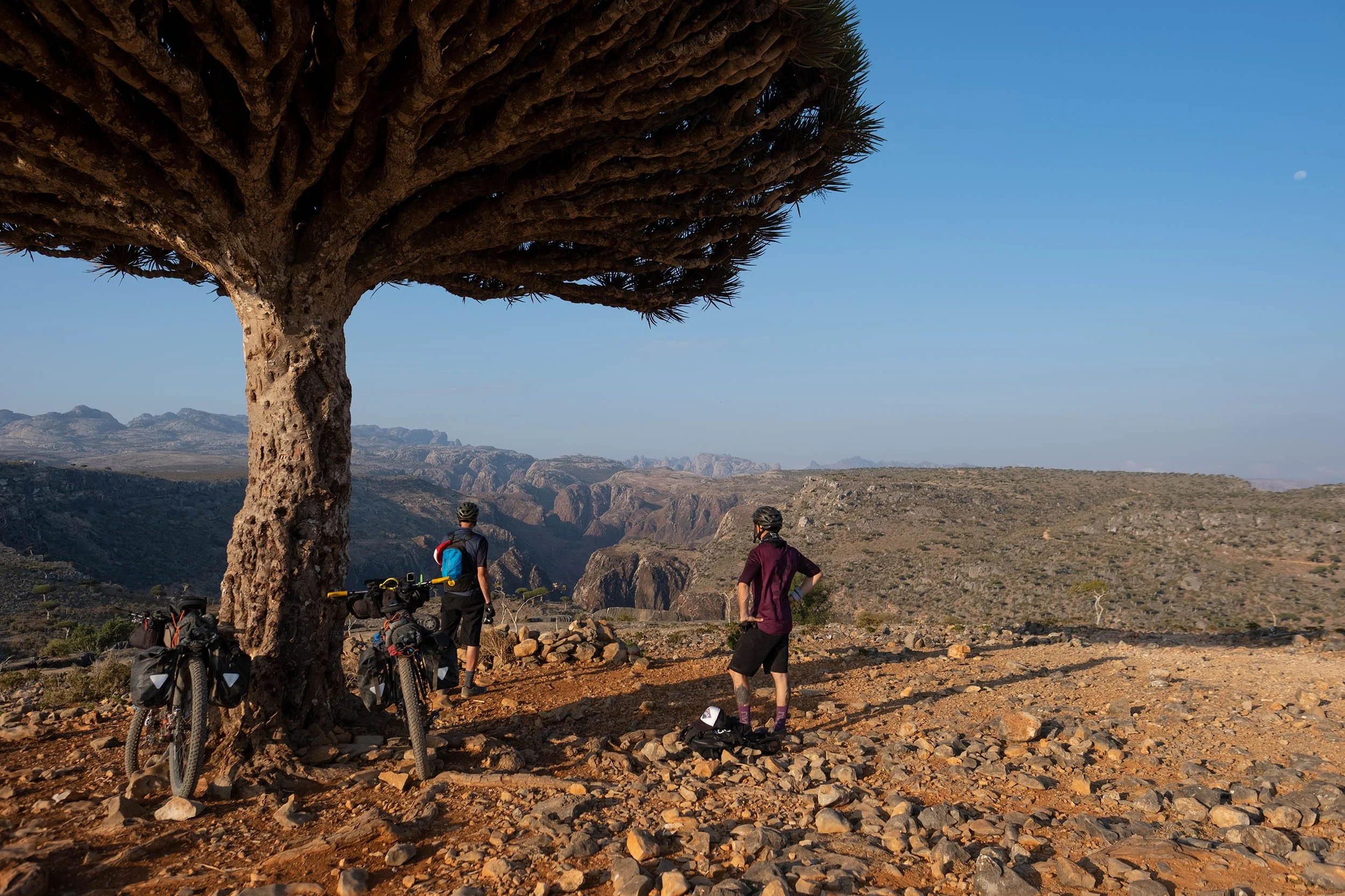
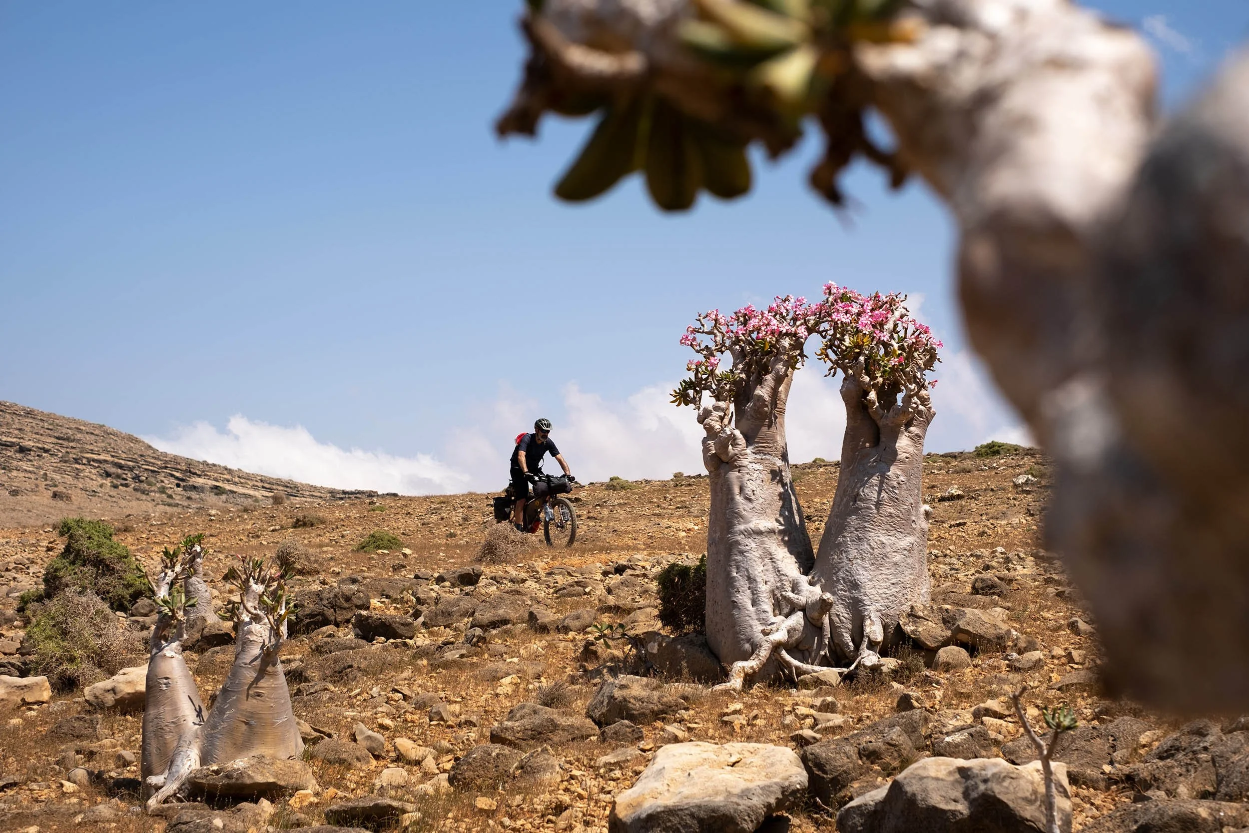
The Dragon Blood Trail was designed to showcase Socotra’s wildest gems, from the postcard-perfect beaches and turquoise waters of Detwah Lagoon to the jagged peaks of the Hajhir Mountains, which rise up to 1500 meters (4,921 feet). The route starts in Hadibo, the island’s capital, then follows the coastline before climbing up to Momi Plateau, a Mars-like landscape with deep red terrain, sharp pyramidal mountains, and bizarre bottle trees, an endemic succulent that thrives in the island’s harsh desert and rocky conditions.
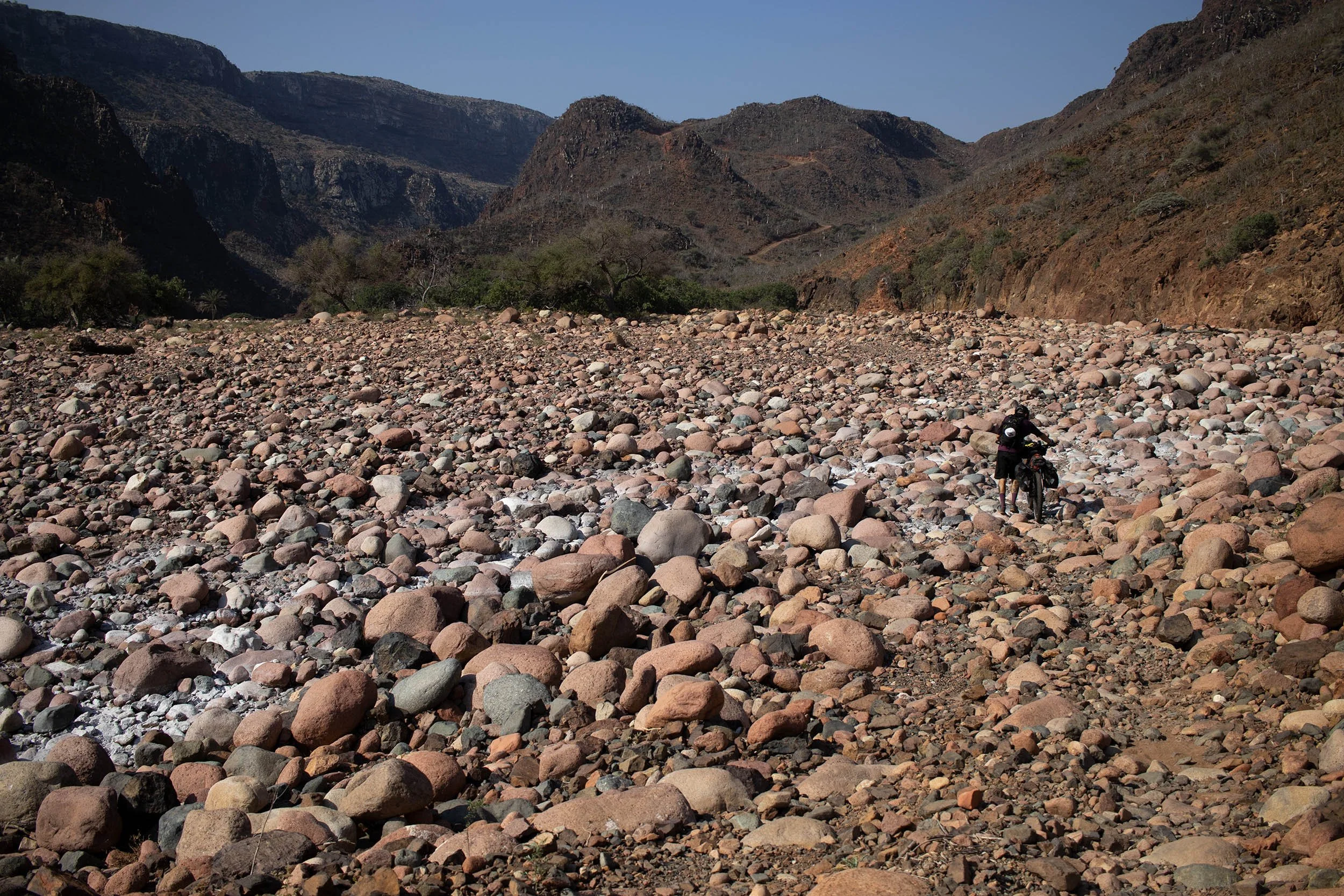
After a gnarly and technical descent into Kalisan Canyon (check out “Route Info”), the trail rolls onto the south coast, where breathtaking beaches sit beneath towering cliffs that drop straight into the Indian Ocean. From here, a series of short but brutally steep climbs and rough descents lead to the Diksam Plateau, home to the Firmihin Forest, the jaw-dropping Wadi Dirhur Canyon, and the dramatic Hajhir Mountains looming in the background. The whole place feels like a lost world straight out of the Mesozoic Era. This plateau also boasts the highest concentration of Dragon Blood Trees anywhere on the island (and on Earth). According to legend, these bizarre, umbrella-shaped trees sprang from the blood spilled in an epic battle between a dragon and an elephant. Their name comes from the deep-red resin, cinnabar, found in their bark and leaves.
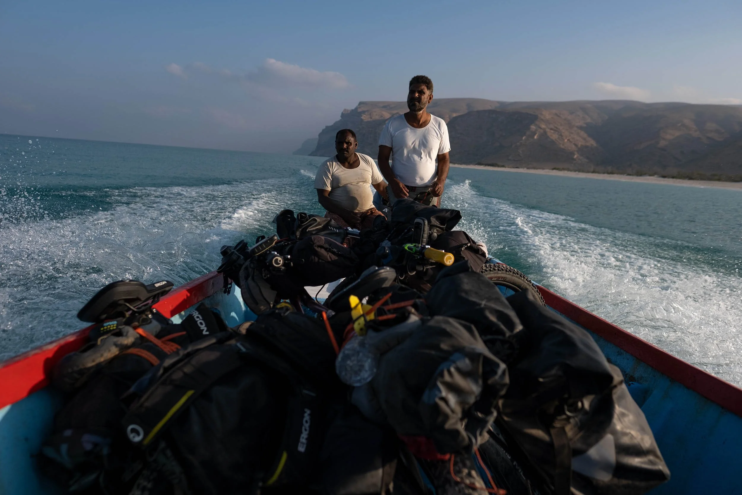
The Dragon Blood Trail follows dusty roads and rugged jeep tracks all the way to Qalansyah, a tiny coastal town on the west coast. From here, you’ll need to hop onto a fishing boat (yep, check out “Route Info” for details) to cross over to Qabahen, a remote village 23 km (14 miles) south in Shoab Bay. Once back on solid ground, the trail cuts through a surreal desert wilderness, filled with strange rock formations and the occasional goatherd’s hut. This isn’t just a bikepacking route—it’s an expedition. The tough terrain, extreme remoteness, and lack of food and water resupply make it a true adventure.


-
Exploring one of the most isolated and infrequently visited places on the planet.
A chance to see many rare and endemic species of plants found nowhere else in the world as the iconic Dragon Blood Tree (Dracaena Cinnabari) and the Socotra Desert Rose or Bottle Tree (Adenium Obesum Socotranum).
Stunning views of otherworldly landscapes with pinnacles of Haggier (Hajhir) Mountains in the background.
Swimming in the wadi’s deep pools to refresh yourself and escape the midday heat.
The impressive sight of Wadi Dirhur, a canyon gashed into the limestone plateau separating Diksam Plateau from the Firhmin Forest.
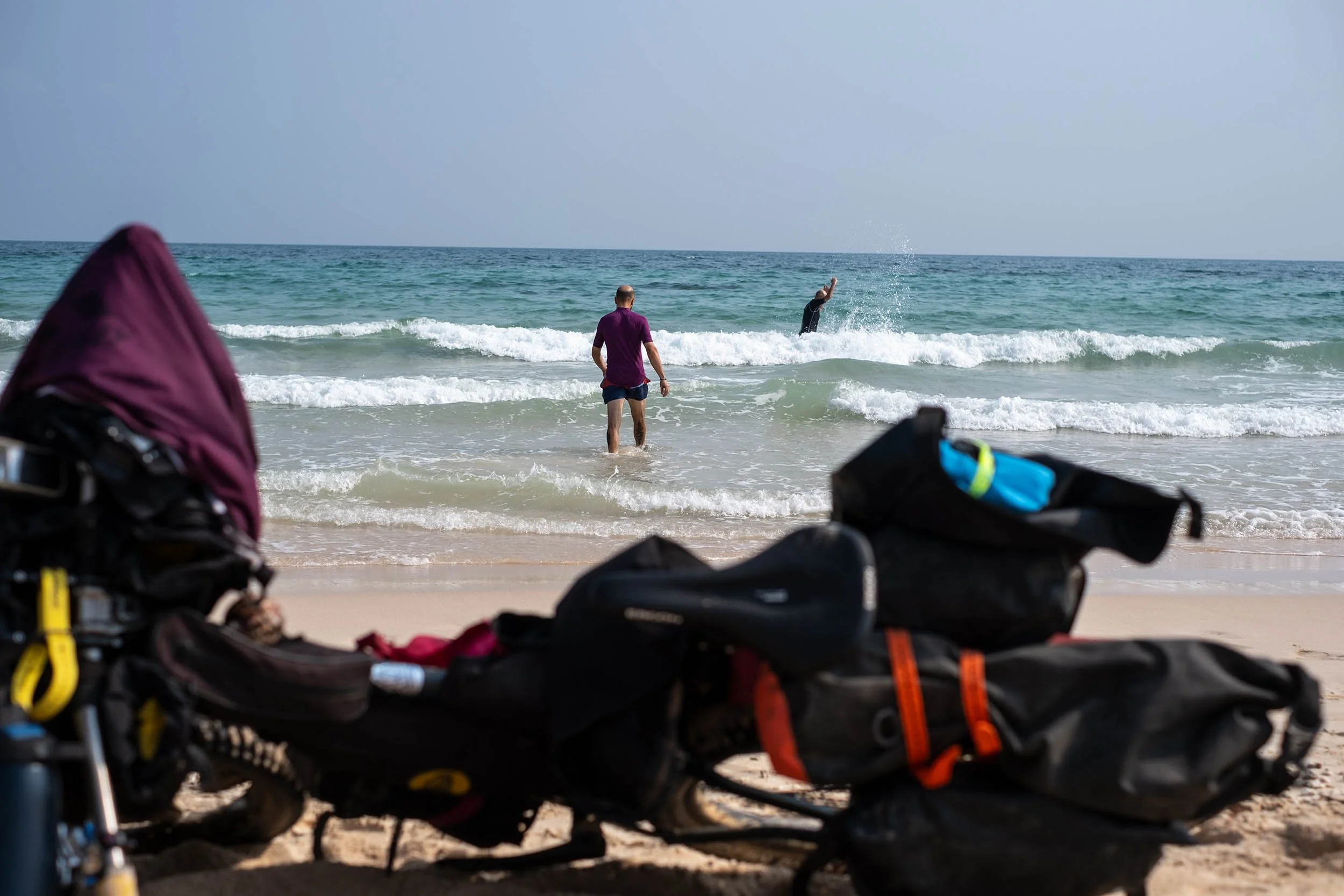
The breathtaking beauty of the Detwah Lagoon characterized by turquoise water and snow-white sand.
The chance to spot some dolphins jumping alongside the boat during your sea transfer from Qalansiyah to Shoab Beach.
The chance to have an ice cream (or more) from a truck with Woody-Woodpecker painted on the side just before the end of the route. That’s not a mirage!
-
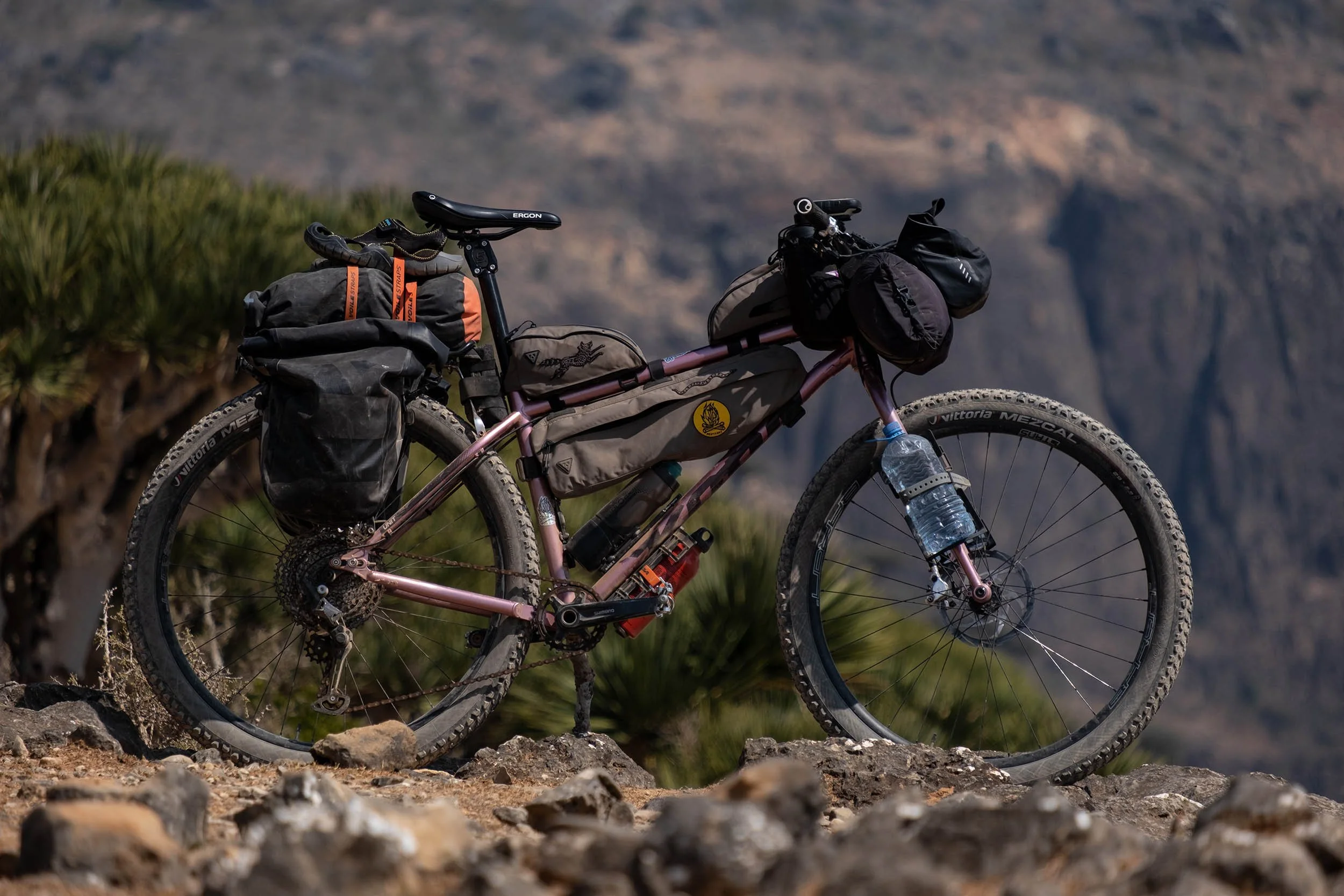
Bikes: we rode Kona Unit Xs with rigid forks and 2.6″ Vittoria Mezcal tires. This setup worked well. Front suspension will be welcome on non-plus/fat bike rigs, especially for riding in the remotest areas where the terrain is really rugged.
Safety: Note that as of July 2023, the US Department of State has issued a “Level 4: Do Not Travel” warning for all of Yemen due to the ongoing civil war. Please visit this page for current details.
This route is best tackled in the dry season, between mid/late January and early March, when the weather is generally dry and relatively cool, plus, the seawater is also calmer and clearer. As an added bonus, the iconic Bottle Trees also begin to bloom in March, revealing picturesque pink. October is also generally a good time to ride this route. Expect some rainy days that fill the wadis with clean and fresh water and make the landscapes lush.
You can reach Socotra with a weekly direct flight from Abu Dhabi. It’s a governmental charter flight, and they do not offer online booking. Flight reservation and visas can be requested only by a local tour operator. We contacted ILoveSocotra.com, and Samed, the Soqotri guy behind the company, was super friendly and helped us also with airport transfer, accomodation, and food supply.
There are only two hotels in Hadibo, the capital of Socotra, but we preferred to stay at Heathrow Hotel (h.h@tcmsuk.com). It’s near the airport and 13 kilometers (8 miles) from Hadibo and offers some rooms with private bathrooms, WiFi, and A/C. They can also store bike trolleys/boxes.
Pressured gas canisters are not available in Socotra. We used a multi-fuel stove (XGK EX Stove by MSR) to cook, since fuel is easy to find in markets or directly in the streets of Hadibo (ask for “ghaz” or “benzina”).
There are no ATMs on the island and credit cards aren’t accepted anywhere, so you need to carry cash. The currency used is the Yemeni Rial (YR), but USD is the most widely accepted foreign currency and easiest to exchange on the island. Euros are also accepted. Rial is the only currency accepted in the highlands and rural areas.
SIM cards can be purchased at Abu Dhabi airport, but consider that most of the route has no signal coverage. A communicator satellite (we used a Garmin InReach Mini 2) can help you staying in touch with your family or send out a request for help if you’re in trouble in the the most isolated parts of the route.
A solar panel and a power bank are recommended for charging devices and camera batteries, since electricity is available only in Hadibo, Qalansiyah, and at Heathrow Hotel near the airport. You have the chance to recharge your phone and small devices at Keabanni Campsite on Diksam Plateau.
Diarrhea and food-borne illnesses are not uncommon ailments of travelers in Socotra. Make sure to pack Imodium and a broad-spectrum antibiotic.
Stay away from camels; they can be aggressive.
The downhill into the Kalysan Canyon is a bit tricky and includes some exposed stretches that can be challenging, especially with heavily laden bikes. The passage is shown in our Socotra film (below) at 2:50.
Be prepared for some hike-a-bike along the route. Short but super-steep climbs in the highlands and sandy roads along the coast will force you to push your bike.
This route involves a sea transfer with a fishing vessel from Qalansiyah to Qabahen, a small village on the Shoab Bay in the southeast coast. Samed of ILoveSocotra.com can help you to arrange the transfer.
text goes here
-
Wild camping will never be a problem on the island. If you decide to camp on the beach, make sure your tent is far enough away from the ocean to avoid getting caught by the high tide.
Keabanni is a campsite with basic lodging on Diksam Plateau where you can take a stop to rest, drink chai, take a shower, and eat traditional Soqotri food.
There is no garbage collection and disposal system in Socotra. It would be good to minimize plastic waste and dispose of it where plastic can be recycled. We brought back home some plastic bags and the bottles we used to carry the water along the route. #Leavenotrace.
-
The only drinkable water on the island is the bottled one sold in markets of Hadibo (close to the start of the route) and Qalansiyah.
Wadis (rivers in the canyons) and some small villages are the only chances for water resupply along the route, and in both cases, water has to be filtered and purified. We used a MSR TrailShot pocket-sized water filter and a Katadyn Steripen Adventurer Opti UV Water Purifier to avoid using chlorine tablets.
Be prepared for some unplanned stops in rural areas, where people are super friendly and invite you in their home to rest, drink sweetened chai, and share traditional food based on rice, goat meat, and hummus.
Food resupply can be found only in markets in Qalansiyah, the second largest town on the island.
As Socotra is hot and dry, make sure to stay hydrated. We carried 5L of water at any one time, three of which were on the front fork.
-
ROUTE DIFFICULTY: 9/10
This ride isn’t for casual travelers. Water scarcity will become an obsession, and you’ll need to filter and purify every drop. Dehydration, stomach issues, and food shortages are real risks, especially in the most remote areas. The terrain is unforgiving—think razor-sharp rocks, deep sand, and steep climbs. A plus bike or fat bike is a must—leave your gravel bike at home.
While the total elevation gain isn’t massive, the heat, rough terrain, and sheer remoteness make this route a serious challenge. Plus, getting there is an adventure in itself—flights can only be booked through WhatsApp, and logistics are tricky at best. There’s just one food resupply point (in Qalansyah), and finding water is tough, especially in the dry season (January-March). Friendly Bedouins might offer water or invite you to share a meal, but you can’t rely on that.
!! WARNING !!
We STRONGLY DISCOURAGE anyone without the necessary skills and mindset for extreme environments—such as mountains, deserts, river crossings, and remote water and food resupply—to follow the routes on this site. These routes are designed primarily for EXPLORATION and are not intended for traditional bike touring. If your experience is solely in cycling, without a solid background in outdoor survival and self-sufficiency, you are STRONGLY ADVISED AGAINST attempting these routes. They demand an adventurous spirit, adaptability, and the ability to handle unforeseen challenges in the field. Proceed entirely at your own risk. While every effort has been made to provide accurate GPS tracks and route information, we cannot guarantee their reliability over time due to factors such as land access changes, property rights restrictions, and the closure of supply points. All the information provided on this site is more than sufficient to ride these routes. Please do not email us requesting additional info about the routes, as you will not receive a response - sorry for that. Further information for every route can be found in the comments on Bikepacking.com (click on “Check it on Bikepacking.com” button). The route creators are in no way responsible for personal injuries, damage to property, or any other incidents that may occur while riding or following these routes.